Thursday 10-11
We woke up pretty early at the Patreksfjörður guesthouse after a good night sleep. We'd been told that we could stay as late as we liked as it was the end of their tourist season and they had no-one else booked in the next day, but we were keen to get moving as we had some big drives ahead of us.
Our first stop was the Dynjandi / Fjallfoss waterfalls in the Westfjords (Vestfirðir) area. The roads there were... interesting... to say the least.
We had thought that the foggy, gravel road near Myvatn was bad, then we worried a little by the gravel road around the coast on the way to Patreksfjörðu, but the road we followed here made those roads look like gold edged, velvet covered cushions. We checked to ensure that they weren't 'highroads' and were suitable for a 2WD car multiple times, and we were reassured that they were. The first road went around the coastline with quite steep drop. The scenery was amazing, but our eyes were locked on the road ahead as we bounced away along through the potholes.
 | ||
| The condition of the road - samples from Googlemaps (it was worse than this - watch the video below) |
Timelapse:
Timelapse:
I had to stop recording at this point because Kris needed to concentrate on driving and I had to keep an eye out for potholes and other hazards. Once things settled back down to just be snow and potholes I started recording again:
Timelapse:
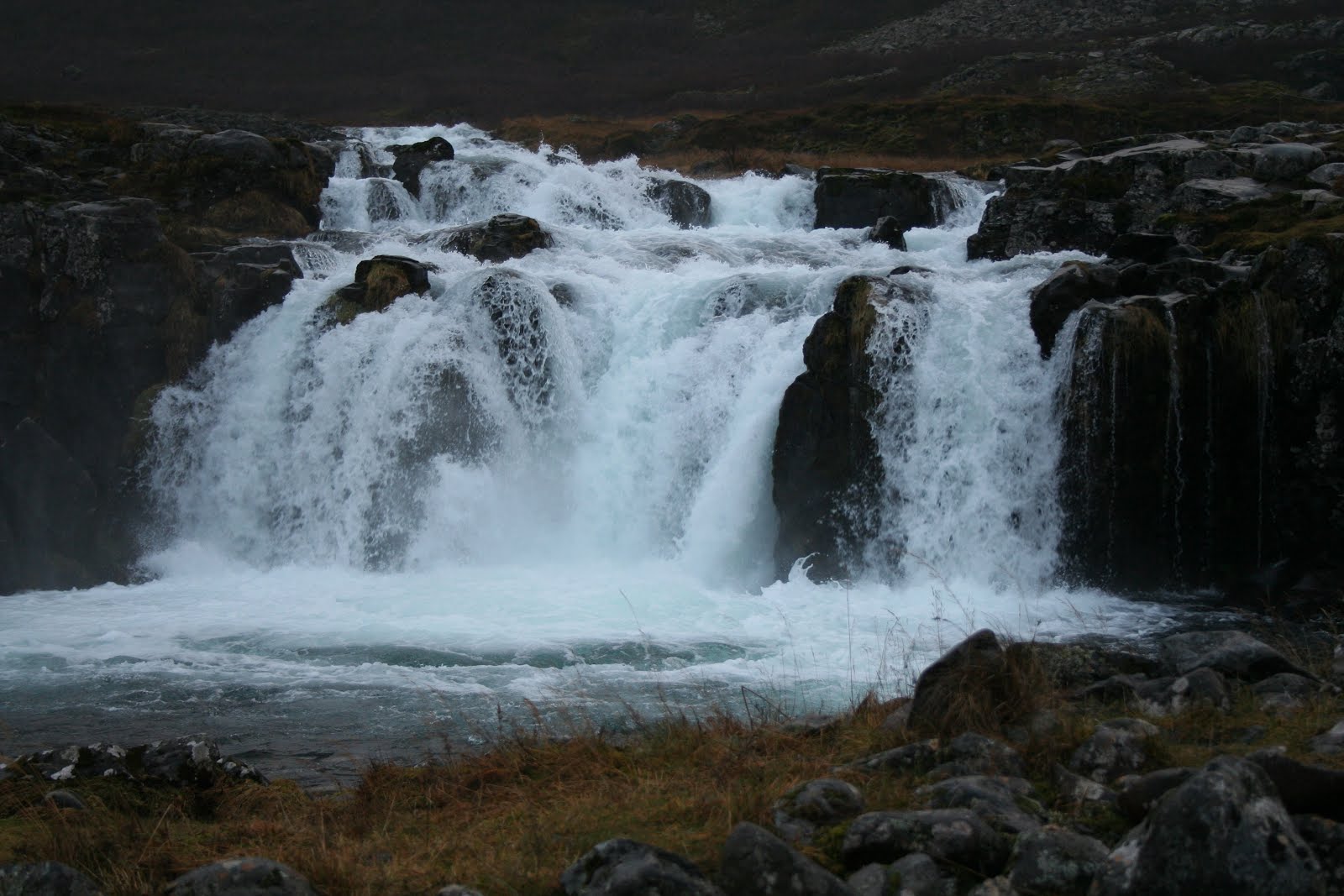
When we finally made it to Dynjandi we were exhausted (which was an achievement for me since I wasn't even driving..) but it was worth it! The falls is a series of falls that we thought was the most impressive of all that we had seen in Iceland. The weather was pretty nasty, but we took the hike up past all the smaller falls to the top. The main fall cascades in a 'bridal veil' formation 100m and then down a subsequent 6 other smaller falls.
The view in the other direction was pretty breathtaking also
 |
| 360 panoramic view |
 |
| Fjallfoss / Dynjandi |
 |
| Information |


 |
| Map of the falls |
The first of the set of falls is Bæjarfoss, the name means "Town falls"
 |
Bæjarfoss |
 |
| Us at Bæjarfoss |
 |
| Bæjarfoss |
 |
| View up to Dynjandi from Bæjarfoss |
Hundafoss:
The second of the falls is Hundafoss, meaning "Dog Falls", there are some suggestions that it was names this as dogs were swept over the falls during floods.
 |
| Hundafoss |
 |
| View up to Dynjandi from Hundafoss |
 |
| Looking back away from the falls |
The next of the falls was Hrísvaðsfoss:
 |
| Hrísvaðsfoss |
 |
| Tomas at Hrísvaðsfoss |
Göngumannafoss:
The next fall was Göngumannafoss ("Hiker Falls"):
 |
| Göngumannafoss |
 |
| Alana and Cameron at Göngumannafoss |
 |
| Göngumannafoss |
 |
| View back down from Göngumannafoss |
 |
| Top part of Göngumannafoss |
Strompgljúfrafoss:
The next fall was Strompgljúfrafoss ("Chimney Gorge Falls"), the second biggest of the falls:
 |
| Strompgljúfrafoss |
 |
| Strompgljúfrafoss with Dynjandi above |
 |
| Looking back over the tiers so far |
 |
| Strompgljúfrafoss |
 |
| Looking back down |
 |
| Top of Strompgljúfrafoss |
Hæstahjallafoss:
The final fall before Dynjandi was the Hæstahjallafoss ("Highest Helm Falls"). Their location made them quite hard to capture and they weren't sign posted like the others (that we could see). In the photo below they are the set of falls falling over the ledge in the middle of the shot, just below Dynjandi.
 |
| Hæstahjallafoss |
Dynjandi:
The final set of falls was the big one, Dynjandi:
 |
| Dynjandi |


 |
| Looking back |
We didn't stay as long as we liked as it started snowing and dropping some pretty big wet raindrops. Our next stop was to be Kirkjufell (a conical mountain) that was about 4hr drive away on the way back to Reykjavik. But I mentioned it was snowing right? And that the roads were gravel and full of potholes? And that we had a 2WD? Remember that section of road I stopped filming at with the timelapse earlier?
Turns out at least another 2cm of snow had fallen while we were exploring Dynjandi and as we tried to climb the rise where I had stopped filming before, the car lost traction on the torn up road and snow and couldn't make it. Kris rolled the car back to the base of the hill and tried again. This time we got some grip on the snow, but the road below was so torn up already that we slipped in the mud and ended up losing traction again. As she tried to reverse back again we ended up slipping and while she maintained control we ended up close to a creek bank and knew that we couldn't risk slipping again. We were in quite a secluded area - the road only went to the falls and we'd only seen a few cars that day. I couldn't risk trying to push as the car could have slipped back onto me, or we could have ended up in the creek. The weather was coming in pretty cold, and while the kids were happy in the back seat playing their IPads, we knew we weren't going to be going anywhere.
We called the roadside assistance number and when I explained that we'd lost traction and were stuck in the snow I was told "There's no snow in Iceland right now." The fat snowflakes and 5cm of snow under my feet begged to differ. In the end they said it would cost 60,000ISK (about $1000 AUD) to send someone to help tow us out due to the distance. They suggested that we wait and see if anyone passed.
A few minutes later some tourists in a 4WD arrived, but they didn't have any tow gear. We tried sitting on the bonnet to help with traction but we couldn't get any grip and if anything we edged closer to the creek. After they left we didn't see anyone else for another 10min, so we decided to bite the bullet and call roadside assist to get us out. Just as I was explaining the situation, another 4WD turned up and this one had tow gear and a driver that knew what he was doing. He managed to hook up the car and after some effort gave us a tow up to the top of the rise.
 |
| Getting a tow (top of the slope) |
We waved thanks to our hero and started back towards Reykjavik - we had lost a couple of hours and all inclination to push on to Kirkjufell (we likely wouldn't have made it in time before it got dark). The shortcut to Reykjavik ended up looking pretty daunting, a snow covered slope as bad as the last one, so we ended up taking the safe option and driving the long way back to Patreksfjörður.
After the 'excitement' we were both completely exhausted and decided to take the easy option and take the Ferjan Baldur (Baldur Ferry) across the bay from Patreksfjörður to Stykkishólmur. Overall it was going to take about the same time as driving, but we would be able to rest for 2 hours, plus there was a chance that we could see the Northern Lights from the ferry. We needed to wait for a couple of hours as the ferry only went once a day, but we got petrol and had a bit of a rest.
The ferry trip was interesting - we got some dinner and then spent the time between sitting inside in the warm and checking outside for the Lights. Unfortunately, our friends the clouds followed us and we never saw any of the lights. The ferry driver promised a smooth crossing but there was still quite a bit of movement and it was fun to try and walk around the deck with the amount of movement.
 |
| The ferry |
 |
| The route |

Total Travel:
Patreksfjörður - Dynjandi - Patreksfjörður - Brjánslækur Ferry- Stykkishólmur (58km - not included as not driven) - Gullsmári,. (402km, 9hrs)
Total distance traveled so far: 2954km
Patreksfjörður - Dynjandi - Patreksfjörður - Brjánslækur Ferry- Stykkishólmur (58km - not included as not driven) - Gullsmári,. (402km, 9hrs)
Total distance traveled so far: 2954km


